Resilience through Remote Sensing


This post was written by Kevin Mulligan, USAID Bureau for Resilience and Food Security, Center for Resilience.

In 1976, Salvador Dali painted an 99 ¼ inch by 75 ½ inch oil painting he called “Gala Contemplating the Mediterranean Sea which at Twenty Meters Becomes the Portrait of Abraham Lincoln - Homage to Rothko (Second Version)” (Figure 1). When viewed up close, we see the nuanced details of the artist’s work and are likely distracted by the dominant figure that is so clearly in focus. However, if the title of the piece didn’t provide sufficient guidance to the novice art enthusiast, Dali provided a more subtle hint by including a blurred portrait of Abraham Lincoln; just to the left of center at the bottom of the piece. The masterpiece was also meant to be viewed at a distance. In effect, Dali had created two pieces of art on a single canvas. If the piece is not viewed from both perspectives, the novice art enthusiast misses out on the true genius of the artist’s work.
Though I never met Dali, I am pretty confident the piece (now on permanent display at the Dali Museum in St. Petersburg, Florida) was not created to help articulate the value of remote sensing in USAID’s humanitarian and development assistance work. I could be wrong; he was, after all, a visionary genius. Nonetheless, it serves as a perfect analogy for such a discussion.
Effective activity design, implementation, and adaptive management requires practitioners to dig deep into the nuanced technical variables within a given context. This approach ensures activities are addressing specific needs by developing and strengthening the resilience capacities at the individual, household, and community level. Our monitoring, evaluation, and learning efforts are similarly understandably focused on gathering and analyzing the data generated from those activities, which ultimately informs the decision-making process.
However, it is challenging to transpose those specific examples of progress into a broader and more compelling narrative that captures the larger impact of our work on a systems, country, or regional level. As custodians of the taxpayers’ dollars, USAID is continually asked to articulate how local investments contribute to advancing a country along their Journey to Self-Reliance. Just as in Dali’s work, remote sensing allows us to take a step back and view the overall impacts of our work from a different perspective. It is not hyperbole to say the view we have available to us is literally out of this world.
Since 2004, NASA and USAID have partnered to end extreme poverty and promote resilient, democratic societies while advancing U.S. security and prosperity. Through the USAID/NASA SERVIR program, supported by a consortium of domestic and international partners, NASA provides USAID with the ultimate “big picture” data generated by its constellation of satellites. USAID overlays detailed data from the local level onto NASA’s Earth observations to show the impact of development assistance activities over time.
SERVIR connects space to villages by helping developing countries use satellite data to address critical challenges in food security, water resources, weather and climate, land use, and natural disasters. USAID leverages this science-based information in data-scarce environments and applies its development expertise and field presence to improve climate resilience, agriculture and food security, water management, health, ecosystem management, and disaster risk reduction. Similar to what Dali accomplished in his masterpiece, the SERVIR partnership integrates USAID’s deep contextual experience with NASA’s remote sensing capabilities to empower decision-makers with the tools, products, and services to act locally to address global climate challenges.
The Tigray region of Ethiopia provides an example of remote sensing’s contribution to assisting USAID to articulate its development assistance efforts. With limited local water availability for agricultural use––especially in the dry season––the food security of the people within Feresmay Town was vulnerable to shocks and stresses (Figure 2). The town’s exposure to climate-related shocks and stresses had adverse multivariate implications for the population, including potential malnutrition, stunting, wasting, reduced economic growth, and psychosocial stresses.
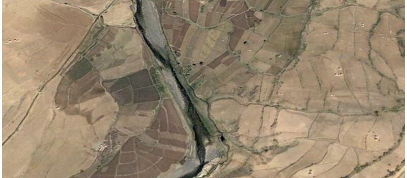
In 2012, through a partnership with the Government of Ethiopia and the Relief Society of Tigray (REST), USAID sought to address these challenges through the installation of a river diversion activity. The observable impacts, for those familiar with the community’s pre-intervention challenges, were remarkable. However, in the years since, visitors to Tigray have not had a frame of reference to compare their observations to. To the indoctrinated, the return on investment was not obvious. Standing on the ground, in the vicinity of the water diversion activity, they could not appreciate how much more resilient––how much more capable of absorbing and adapting to shocks and stresses––the community had become. They simply couldn’t see the changes that had occurred over time (Figure 3). To provide the requisite perspective, USAID/NASA SERVIR helped articulate a more compelling narrative.

NASA/SERVIR investigated the normalized difference vegetation index (NDVI), or “greenness,” to help observers understand the impact and value of the activity over time. NDVI was assessed before, during, and after the date of the project’s completion. NASA researchers observed the distinct colors (wavelengths) of visible and near-infrared sunlight reflected by the plants within the activity area. The pigment in plant leaves, chlorophyll, strongly absorbs visible light (from 0.4 to 0.7 microns) for use in photosynthesis.
The pre-intervention analysis provided a baseline understanding of how much water was available for irrigation, crop production volumes, and general insight into the community’s food security challenges. In subsequent years, after the water diversion activity, SERVIR captured data on the greenness of the vegetation in the vicinity of the site. The ex-post analysis showed the activity’s intervention facilitated visible and sustained results (Figure 4).

The data highlight a remarkable increase in the greenness of vegetation throughout the year, as demonstrated by the gap between the red (pre-intervention) and green (post-intervention) trendlines in Figure 4, and the side-by-side imagery in Figure 5. Importantly, the data shows greenness is observed during the dry season (September through March). This means the community can now produce food throughout the year, making the people more food-secure; increasing local access to nutritious foods; and increasing the absorptive capacity to be resilient in the face of shocks that come with drought conditions.

This theory was tested during ‘shock years” (2013-1015) when low rainfall was offset by the community’s increased availability of water. Though these observations do not yet meet the scientific threshold for attributing causation for this observed resilience to the water diversion activity, it is certainly a compelling narrative.
Looking to the future, USAID is taking a page from Dali’s playbook and overlaying additional data to investigate how other investments’ contributions are increasing the resilience capacities of individuals and households within the broader community. Evaluating variables like agricultural production, dietary diversity, malnutrition levels, stunting levels, and water security, sanitation and hygiene progress will provide additional details that are important for communicating the value of USAID investments. What started as an analysis of one relatively small activity has implications on a national and regional level. As elected officials and private sector investors see the value of collecting and applying remote sensing data, we can anticipate they will seek to leverage more advanced analyses to inform their data-driven decision making processes and investments.
USAID is leveraging the use of remote sensing to develop the capacity of government ministries to make data-driven decisions by conducting these kinds of analyses at scale. The combined impacts on individuals and households within a community have the potential to transform the way leaders view and use data to strengthen their capacity to plan for and mitigate the risks of climate-related disasters. The demonstrated capacity to systematically and transparently use data to drive decisions and deliver basic services will strengthen the resilience of countries and systems to the shocks and stresses they must manage (Figure 6).

For example, one of the strategies being used to conduct disease surveillance may also be an effective way to anticipate and target impending locust outbreaks. NASA scientists are working on an approach that uses satellite imagery to identify locust breeding sites that can be eliminated before the insects hatch and spread.
Locusts lay their eggs in warm, moist, sandy soil. Until now the best available tools for tracking and forecasting locust movement relied on rainfall as a proxy for soil moisture to predict where they might breed in large numbers. A NASA/USAID SERVIR initiative is helping the United Nations Foreign Agriculture Organization (FAO) integrate high-resolution soil moisture data from land surface modeling, which can estimate soil moisture at egg-laying depth, into maps with much more detail on soil type. Combining locust observations with soil type and moisture data can help identify optimal areas for egg-laying and target control measures early (Voorhies 2020).
Implementing this technology and taking decisive action with the intelligence it produces requires commitment from regional stakeholders. The benefits of using such technology enable us to respond more efficiently now, to protect the hard-fought gains realized in places like Tigray, Ethiopia, and avoid locust and other pest crises in the future. It is essential to scale up the resources to meet the need, address the barriers, and realize the innovations in surveillance that are needed to address the full range of our development objectives. Protecting crops and livestock will save lives and provide urgently needed income for farming households, putting the region on a much firmer footing to be resilient in the difficult days ahead.
As Dali has shown through his work, it is essential to keep both the strategic and tactical perspectives in focus. The USAID/NASA SERVIR partnership helps the Agency maintain that clarity, through the combined application of state-of-the-art field-based interventions and advanced remote sensing technologies.